[source: VDO Dayton]
 With the portable navigation system PN 2050, VDO Dayton is introducing a new gem in the cockpit. The company has transferred its many years of know-how gained from fixed in-car navigation systems into the elegant and powerful route planner, making straightforward and precise route guidance possible. Higher-speed processors and more sensitive GPS receivers improve the performance even further. A unique light sensor automatically adapts screen brightness to the ambient light level. In addition, further modules can supplement the functions of the PN 2050 by TMC and Bluetooth, for example
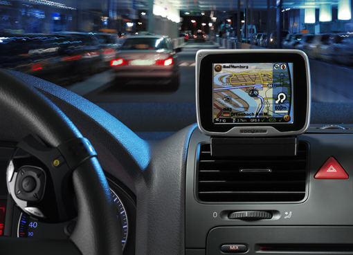
The outstanding characteristics of the new system include its elegant design, high-quality material selection and extremely slim form. Although the screen size has the common 3.5 inches in diagonal format, the PN 2050 is not much bigger than the latest multi-media cell phones. A brightness sensor automatically adapts the luminous intensity. Whether during the day, at night or in twilight conditions, the high-resolution color display can be optimally read at all times.The attractive exterior houses an extremely intelligent core. To achieve this, VDO Dayton transferred all its know-how gained from fixed in-car navigation systems to portable navigation. Operation is intuitive, and the route guidance corresponds to the fixed systems from VDO Dayton almost completely in terms of speed, choice of route, symbols and spoken instructions. With the change in generation, VDO Dayton has also further improved the hardware. The new processor is 30 percent faster than its predecessor and the GPS receiver is even more sensitive.There are three versions of PN 2050 available: VDO Dayton supplies the basic version without TMC with a standard cradle. As an option, the device can also be ordered with an active cradle, including integrated TMC receiver for dynamic route guidance. The PN 2050 can be connected directly to the vehicle’s electric and audio systems by means of an additional cable. In this case, the navigation system starts up on ignition, the music is muted when instructions are spoken, and speech or MP3 files are reproduced through the loudspeaker system. A third version offers a Bluetooth connection for hands-free use of the cell phone and the playing of audio files. The way the unit can be integrated in the vehicle is further clear proof of VDO Dayton’s long years of experience: PN 2050 can not only be attached to standard windscreen cradles, but can also be integrated into the vehicle like a permanently installed system, with various installation solutions available. It is this possibility in particular which unites the advantages of permanently installed and portable navigation systems. On the one hand, the driver can enjoy optimum quality, maximum safety and aesthetic installation without tangled wires. And on the other hand, the device can still be reinstalled in another vehicle in next to no time, be removed and taken along on business or holiday trips, or to the office desk for data updates and route planning.Because portable navigation systems are much more than just pathfinders, VDO Dayton has integrated numerous multi-media functions in the extremely versatile PN 2050 which has no less than 21 menu languages. These functions range from an automatic slide show through MP3 player to Sudoko games, for example. These data, like the road map, are stored on an SD card and can even be recalled parallel to the navigation function. Thanks to the replaceable lithium-ion battery, a permanent power supply is not required for this.