MobiNav

All Things Mobility

avril 29th, 2012

DARPA Seeks New Inertial-Atomic Sensor

[Source: Inside GNSS]

The Defense Advanced Research Projects Agency (DARPA) has launched a search for an atomic inertial sensor to measure orientation in GPS-denied environments. The Chip-Scale Combinatorial Atomic Navigator (C-SCAN) initiative seeks to create a sensor that integrates small size, low power consumption, high resolution of motion detection, and a fast startup time into a single package.

“When GPS is not available, gyroscopes provide orientation, accelerometers provide position, and oscillators provide timing. The new C-SCAN effort focuses on replacing bulky gyroscopes with a new inertial measurement unit (IMU) that is smaller, less expensive due to foundry fabrication and yields better performance.”

mars 26th, 2012

Galaxy Note integrated GPS: Broadcom BCM47511 GNSS

[Source: Broadcom]

The BCM47511 SoC solution is Broadcom’s latest generation of standalone receivers, featuring both integrated GPS and GLONASS. By leveraging the United States NAVSTAR Global Positioning System (GPS), Russia’s Globalnaya Navigazionnaya Sputnikovaya Sistema (GLONASS), Japan’s Quasi-Zenith Satellite System (QZSS) and the Satellite Based Augmentation Systems (SBAS), users have access to 59 satellites currently in orbit — nearly twice the coverage of GPS alone.

We can check here for more information about Broadcom’s BCM47511

mars 21st, 2012

Work Begins on Strengthening EGNOS against Solar Storms

[Source: GPS world]

EGNOS signals are potentially vulnerable, however, to the effects of high solar activity on the ionosphere — the electrically active upper layers of our atmosphere — which can cause signal « scintillations » and time delays.

This new effort will increase system robustness and service availability against severe ionospheric severe effects that began last year and are expected to continue until the peak of the solar cycle expected in 2013–14.

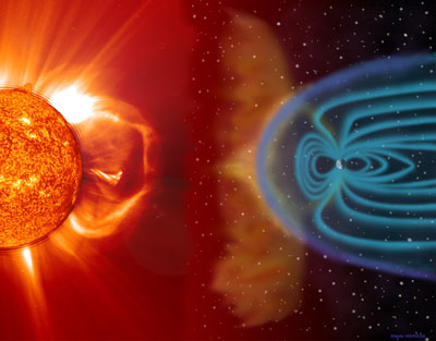
This illustration shows a CME blasting off the Sun’s surface in the direction of Earth.
The left portion is composed of an EIT 304 image superimposed on a LASCO C2 coronagraph.
Two to four days later, the CME cloud is shown striking and beginning to be
mostly deflected around the Earth’s magnetosphere. The blue paths emanating
from the Earth’s poles represent some of its magnetic field lines. The magnetic
cloud of plasma can extend to 30 million miles wide by the time it reaches earth.
These storms, which occur frequently, can disrupt communications and navigational
equipment, damage satellites, and even cause blackouts.

août 18th, 2008

Improving GPS Accuracy for Urban Pedestrians

Mass market GPS applications have mainly focused on car navigation over the last five years and contributed to the wide-spread use of GPS receivers. A wide range of applications can be foreseen for pedestrians as well: multimodal navigation, local search, and social networking are a few. But the roll out of most accuracy-critical applications like e-tourism has been slowed by the difficulties of GPS-based positioning for pedestrians in urban areas.  more >>

août 7th, 2008

Boeing Awarded Contract for GPS Enhancement Demonstration

The Boeing Company has been awarded a $153.5 million U.S. Naval Research Laboratory contract to demonstrate High Integrity Global Positioning System (GPS) technology concepts. The contract is expected to run through 2010. more>>

juillet 2nd, 2008

SiGe Launches GPS Radio with Dual-Antenna Capability

SiGe Semiconductor, Inc. has released the SE4150L GPS radio receiver featuring dual-antenna input capability for developing GPS products. The SE4150L is sampling now to lead customers and will be widely available beginning in July 2008. The device is supplied in a 4×4-millimeter QFN package, and is priced at less than US $1.50 in 10,000 quantities. The companion SE4150L-EK1 evaluation board and user guide can provide on-site applications assistance to customers for the design and integration of a complete GPS system. (>> more)

juin 9th, 2008

Perspectives by Eric Gakstatter

This may be the most important column I’ve ever written. It’s certainly the most expensive. At $40,000 worth of equipment for this writer, multiplied by 17,346 readers, we’re talking $694 million. And that’s not nearly the full extent of industry impact; the Department of Commerce has some figures that I will quote later.

Is Dual-Frequency GPS — As We Know It — Becoming Obsolete?
On Friday, May 16, 2008, the Office of Space Commercialization issued a Notice for Public Comment. In it, the U.S. Department of Defense (DoD) proposes to discontinue supporting P(Y) codeless/semi-codeless on both GPS L1 and L2 frequencies on modernized satellites (Block IIR-M, Block IIF and Block IIIA/B/C) beginning December 31, 2020. After 2020, legacy dual frequency receivers may still work, but the DoD would no longer assure that P(Y) power levels and the navigation message would remain the same. Therefore, the civil GPS community has no assurance that legacy dual frequency receivers will operate as before.

Essentially, this means that every dual frequency receiver designed in the 1980′s, 1990′s and many in the early 2000′s would become virtually obsolete. In the interest of disclosure, that includes my own legacy real-time kinematic (RTK) system.

I caution you … it is very easy to rush to judgment regarding this proposal. When I first read it, my first response was « Whoa, dude, no way! » However, it’s important to take a deep breath and work your way through the logic. Your conclusion may be the same as your initial response, but at least you’ve thought it through. That being said, you must also realize that this is the first action, in the history of GPS, which will render a massive amount of GPS equipment obsolete. read more>>
|