CCID Consulting statistics show that the market size of LBS reached CNY 485 million ($71 million) in the first half of 2008, LBS being defined as “value added services that are provided by operators to provide location, navigation, and other services to mobile phone users through SMS, WAP, and other methods”. CCID estimates that, for the entire year 2008, LBS revenue will be around CNY 1 billion (S146 million). CCID Consulting forecasts that LBS will achieve rapid growth as 3G users and services develop; in 2012, the LBS market revenue is expected to reach CNY 3.8 billion ($560 million). more>>
MobiNav
All Things Mobility
WorldView-1 Satellite Sensor
[Source: Satellite imaging corporation ]
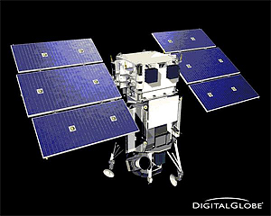 WorldView-1, DigitalGlobe’s earth imaging satellite, completed a successful launch from Vandenberg Air Force Base, California, U.S.A., at 11:35 Hrs Pacific Daylight Time (PDT) on September 18th, 2007. The Delta II rocket lifted off in good weather and the WorldView-1 satellite is « currently undergoing a calibration and check-out period, » according to DigitalGlobe. The first panchromatic image data should become available before October 18th, 2007.
The high-capacity, panchromatic imaging system features half-meter resolution imagery. Operating at an altitude of 496 kilometers, WorldView-1 will have an average revisit time of 1.7 days and will be capable of collecting up to 750,000 square kilometers (290,000 square miles) per day of half-meter imagery. The satellite will also be equipped with state-of-the-art geo-location accuracy capabilities and will exhibit stunning agility with rapid targeting and efficient in-track stereo collection.